TCP Scancyr For Tunnels
Description
Tcp Scancyr for Tunnels
| Requirements | |
|---|---|
| Formats | Generic: text (TXT,XYZ), ASTM E57 (E57), ArcView (ASC) Scaner Point Cloud: Topcon (CLR, CL3), Leica( PTS,PTX), Faro (FLS), Leica MS-50 (XCF) LlDAR Point Cloud (LAS/LAZ) |
| Operating System | Windows XP,Vista,7 ,8, 8.1, 10 in 32 and 64 bits |
| Peripherals | Mouse CD-ROM Reader |
| Graphics Card | Minimum Resolution 1024×768 pixels, Compatible with openGL |
| Hard Disk | 10 GB of free disk space |
| Memory | Minimum 2GB |
| Processor | Dual-core 2Ghz or better |
Overview
Input Data
Horizontal and vertical alignments and super elevation data, via numerical input or conversion from other commercial formats.
Theoretical tunnel templates, which can consist of various layers, defined by parameters or by importing a DXF file. Once this data has been defined, the information from the points taken from the scanner is added via a set of coordinate files either with optional intensity and color.
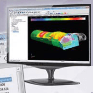
Visualization of Points
Points may be examined using a three-dimensional viewer, with the option of changing between orthogonal and perspective view. Camera position can be controlled directly on the alignment or on a relative position, allowing the station and height to be altered. The level of presentation detail can be modified in order to optimize speed. The symbology assigned to the points may be configured using a variety of method ssuch as angle, height difference, displacement, natural color, intensity, in/out, etc. The application also includes interactive tools for filtering points based on several criteria.
Enquiry Form
Download Brochure
DownloadDescription
Tcp Scancyr for Tunnels
| Requirements | |
|---|---|
| Formats | Generic: text (TXT,XYZ), ASTM E57 (E57), ArcView (ASC) Scaner Point Cloud: Topcon (CLR, CL3), Leica( PTS,PTX), Faro (FLS), Leica MS-50 (XCF) LlDAR Point Cloud (LAS/LAZ) |
| Operating System | Windows XP,Vista,7 ,8, 8.1, 10 in 32 and 64 bits |
| Peripherals | Mouse CD-ROM Reader |
| Graphics Card | Minimum Resolution 1024×768 pixels, Compatible with openGL |
| Hard Disk | 10 GB of free disk space |
| Memory | Minimum 2GB |
| Processor | Dual-core 2Ghz or better |
Overview
Input Data
Horizontal and vertical alignments and super elevation data, via numerical input or conversion from other commercial formats.
Theoretical tunnel templates, which can consist of various layers, defined by parameters or by importing a DXF file. Once this data has been defined, the information from the points taken from the scanner is added via a set of coordinate files either with optional intensity and color.
Visualization of Points
Points may be examined using a three-dimensional viewer, with the option of changing between orthogonal and perspective view. Camera position can be controlled directly on the alignment or on a relative position, allowing the station and height to be altered. The level of presentation detail can be modified in order to optimize speed. The symbology assigned to the points may be configured using a variety of method ssuch as angle, height difference, displacement, natural color, intensity, in/out, etc. The application also includes interactive tools for filtering points based on several criteria.