

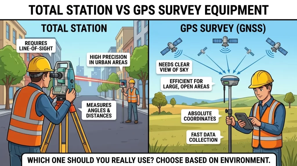
If you’ve spent any time on a job site, you’ve probably heard the same debate raging between two camps: total station purists and GPS survey equipment converts. While the argument may make it sound that way, the truth isn’t so dramatic. A total station and GPS survey equipment (RTK GNSS receivers, to be exact) are not competitors, but two specialists on the same team. One is designed for millimeter accuracy over short, line-of-sight distances. The other is designed for speed and coverage over open terrain.
This guide explains exactly how a total station stacks up against GPS/GNSS survey gear—accuracy, range, cost, workflow, and the specific types of projects each one wins—so you can build a survey toolkit that actually matches the work you do.
What Is Total Station
A total station is an optical-electronic surveying instrument that combines two technologies in one unit: an electronic theodolite (which measures horizontal and vertical angles) and an Electronic Distance Measurement (EDM) module (which measures the distance to a target using a laser or infrared beam, usually a prism mounted on a survey pole).
Set the total station over a known point, sight a target, and it instantly calculates the target’s 3D coordinates using trigonometry. Modern total stations incorporate an onboard microprocessor and data collector, so coordinates are logged, stored, and frequently streamed directly into CAD or design software in the field.
There are generally two types of total stations, and the difference between them is critical for crew planning:
A surveyor manually points a conventional total station at each shot. It’s accurate and reliable, but it requires a second crew member to be out at the prism, since the instrument operator has to sight and lock onto the target manually for each point.
A motorized total station (often called a robotic total station) is equipped with servo motors and automated target-tracking to aim itself and follow a moving prism. With that, a single surveyor can do the survey work without needing a rod person. That’s a big reason motorized total stations have become the norm on the busier construction sites, even when they cost more than a traditional total station.
Typical Accuracy of Total Stations
A quality total station in optimal condition will provide the following:
Distance accuracy: about ±(1.5 mm + 2 ppm), i.e., at typical survey distances, about 2–3 mm
Angular accuracy 1-5 arc-seconds based on instrument class
Effective range: up to about 1,500m to prism targets in normal use, and several kilometers with specialized reflectorless or long-range prisms
That level of accuracy is why total stations remain the instrument of choice wherever a project cannot afford error—from building foundations to structural column layout to bridge alignment and deformation monitoring.
Motorized Total Station vs. Conventional Total Station
Before even comparing total stations to GPS, it’s worth settling the total-station-vs-total-station question, since it changes your crew size and budget just as much as the GPS decision does.
Factor Conventional Total Station Motorized (Robotic) Total Station Target aiming Manual — operator sights the prism by hand Automatic servo motors track the prism Crew size: two people (instrument operator + rod person) One person’s speed on repetitive shots Slower, limited by manual sighting Faster once locked onto the prism Upfront cost: Lower, Higher, Best fit: Small crews on a budget, occasional survey work, teaching/training use, production surveying, construction layout, stakeout-heavy projects
A conventional total station is still a fine instrument—the underlying angle and distance measurement technology is the same as inside a motorized model, and the accuracy specs are usually the same. The only difference is in the aim of the instrument. A conventional total station is often the smarter purchase for firms that do occasional survey work or train new staff. For crews working stakeout and layout all day, the money saved in labor usually covers the additional cost of a motorized total station within a season.
How an Auto-Level Fits In
It’s easy to lump all optical survey instruments into the “total station” category, but an auto-level (aka automatic level) is a simpler, different instrument, and it’s helpful to know where it fits in before you go shopping for equipment.
An auto-level can only measure elevation. It cannot measure horizontal angles or distances like a total station or GPS rover. Mount it on a tripod, read a graduated rod through the telescope, and you’ll have an accurate difference in height between points. The “auto” in auto-level refers to an internal compensator that keeps the line of sight perfectly horizontal, even if the instrument isn’t sitting perfectly level.
Auto levels are:
Much cheaper than a total station or GPS rover
Very accurate for vertical work. Occasionally it’s more accurate than a total station for pure leveling work like establishing benchmarks, checking foundations, and grading.
Limited in scope—no horizontal coordinates, no data logging, no distance measurement to a remote point
You’re working on elevation only, so employ an auto-level—checking a foundation level, running a benchmark loop, or grading a site—and reserve the total station or GPS rover for anything that requires horizontal position, angles, or 3D coordinates.
What Is RTK GNSS (GPS Survey Equipment)?
The common industry shorthand for GNSS RTK systems—real-time kinematic receivers that use satellite constellations (GPS, GLONASS, Galileo, and BeiDou) to determine position—is “GPS survey equipment.” Consumer standalone GPS is only accurate to a few meters, which is nowhere near good enough for professional survey work. RTK fills that gap.
An RTK configuration consists of two parts: a base station, which is set up over a known or arbitrary fixed point, and a rover, which is carried by the surveyor over the site. The base compares its known position to the raw satellite signal and sends a correction to the rover, either through radio or through a cellular/NTRIP link to a CORS network. This correction reduces the positioning error from meters to centimeters in real-time.
Typical RTK GPS Accuracy
Horizontal accuracy: ~8-25mm under good satellite fix
Vertical accuracy: often 2-3x worse than horizontal accuracy so plan surveys accordingly
Effective range: Several km from a local base station via radio, and up to 15–20km or more with network RTK/CORS corrections
GNSS does not rely on the optical line of sight between two instruments, so a rover can move quickly from point to point across large, open areas without the need to reposition a base every few hundred meters.
Total Station vs. GPS Survey Equipment: A Side-by-Side Comparison
Factor Total Station GPS Survey Equipment (RTK GNSS) Typical accuracy: 2–3 mm, 8–25 mm horizontal (worse vertically) Effective range: Up to ~1,500 m (line of sight) Several km to 15–20 km+ with network RTK Line of sight required Yes, between instrument and target No—it needs open sky view insteadWorks under tree canopy / indoors? Yes, poorly or not at all. Works in urban canyons? Yes. Often degraded (multipath errors) Setup time per point Slower—repositioning needed for large sites Fast—rover moves freelyCrew size (robotic model) 1 person, 1 person Best for Construction layout, structural work, tight tolerances Boundary, topographic, and large-area surveys Typical cost: Mid-to-high, varies by robotic vs. manual Complete rover/base kits commonly run $2,000–$3,400+ for working setupsOngoing costs: Minimal NTRIP/CORS subscriptions, software licenses
Where the Real Difference Shows Up: Accuracy
This factor is normally the deciding point. A total station (operating within its optical range) is about 5 to 10 times more precise than RTK GPS. That precision advantage compounds because total station error doesn’t accumulate against a satellite signal—it’s measured directly, point to point.
However, RTK GNSS measures each point relative to the base station or network correction, eliminating error propagation across a chain of points, which can occur with older total station traverse methods. Its accuracy is good enough for most engineering and land work, but it’s still an order of magnitude behind a total station when a project really needs millimeter tolerances—think precast panel alignment, machine tooling references, or bridge bearing placement.
Range and Site Demands
Total stations need an unobstructed optical line of sight to the prism. That makes them the go-to option indoors, in parking garages, under thick tree cover, and in urban settings where tall buildings block or reflect satellite signals (a problem called multipath error). The tradeoff is range. Once a site gets larger than about a kilometer or so, or line of sight is broken by terrain, the crew has to physically move and re-establish the instruments.
RTK GPS completely changes that tradeoff. It doesn’t care about line of sight between points; it just needs open sky. This makes it dramatically faster across highways, farmland, pipeline corridors, and large open parcels where a total station would need dozens of repositions. However, if you place the same rover under heavy tree cover or between skyscrapers, it quickly loses accuracy, sometimes to the point of being unusable.
Efficiency and Speed
RTK GPS is just faster for large, open sites. A single operator can log hundreds of points a day without setting up a backsight or hauling a total station between locations. A total station (especially a robotic one) is faster in practice for tight, detailed, or obstructed sites because it doesn’t burn time chasing a satellite fix or fighting multipath error.
Cost Factors
Neither system is cheap, and the answer to “Which is pricier?” depends on what you’re comparing:
RTK GPS kits (rover, base, controller, and accessories) for professional work typically cost $2,000–$3,400+ before ongoing NTRIP/CORS subscription fees, software licenses, and—if using a UHF radio—an FCC radio license.
Total stations, particularly robotic ones, may cost more initially but have a lower total cost of ownership, as there are no recurring subscription costs once the instrument is purchased.
Labor costs matter, too: a robotic total station or a GNSS rover allows one-person crews, reducing the labor overhead of the traditional two-person total station setup.
When to Use a Total Station?
The project needs millimeter accuracy—building foundations, structural steel, precast alignment, bridge and dam monitoring,
You are working indoors, underground, or in dense urban areas where GNSS signals are unreliable
The site is heavily shaded and there is no clear view of the sky
You need construction stakeout with tight tolerances directly tied to design coordinates
The project area is small enough that moving about is not a big time expense
RTK GNSS GPS Survey Equipment: When to Use
When to reach for RTK GPS:
You’re covering large, open areas—farmland, highway corridors, large parcel boundaries, pipeline routes
The site has a clear sky view without obstructions
For topography or GIS mapping you need to get hundreds or thousands of points in a short period of time
Centimeter accuracy is sufficient for the deliverable (most boundary and topographic work qualifies)
You want to keep crew size and setup time to a minimum over a sprawling site
The Hybrid Method: Why Most Pro Crews Use a Mix
Most surveying firms, in practice, don’t pick a side—they use RTK GNSS to quickly establish primary control points over a large area, then bring in a total station to refine and confirm the detailed, high-precision work from those control points. This hybrid workflow offers the speed of GPS and the precision of a total station without forcing a compromise on either.
In general, this approach is the smarter long-term answer if you’re building out a survey equipment budget. A capable motorized total station for detailed and obstructed work, plus an RTK GNSS rover/base system for open-area coverage and fast control network setup—and a basic auto-level is handy for quick elevation checks that don’t justify setting up either one.
More Information
Is a total station more accurate than GPS?
Yes, a total station is typically 5-10 times more accurate than RTK GPS for direct point-to-point measurements in its optical range: millimeter versus centimeter.
Is GPS survey equipment a total station alternative?
Not all projects. RTK GPS has difficulty in tree cover, indoors, and near tall buildings. While it is accurate, it is not accurate enough for work that needs millimeter tolerances. Most crews use both instruments for different portions of the same project.
Does RTK GPS need line of sight?
No, RTK GPS requires a clear view of the sky to talk to satellites, but it doesn’t require line of sight between the base and the rover like a total station does between the instrument and the prism.
Which is better for construction layout, a total station or GPS?
For tight tolerance layouts, such as structural columns or foundations, a total station is the norm. RTK GPS is usually fast enough for large-scale grading, road alignment, or utility corridor layout.
What is the difference between a conventional and a motorized total station?
A conventional total station requires two operators to aim manually at the prism for each shot. A robotic total station uses servo-driven auto-tracking to follow the prism by itself so that one surveyor can handle the whole job. Usually the differences are aim, crew size, and price. Both have underlying angle and distance accuracy.
The auto-level is not a total station.
Naw. An auto-level only measures elevation differences between points and cannot measure horizontal angles, distances, or coordinates. A total station measures the full 3D position. Auto-levels are cheaper and more convenient for pure leveling, but they cannot replace a total station or GPS for layout or boundary work.
Auto-levels and total stations are different tools for different jobs.
Usually yes, if your work involves anything but elevation checks. An auto-level does a good job with vertical measurement, but any project requiring horizontal coordinates, angles, or stakeout—which is most construction and land surveying work—still requires a total station or GPS.
The Bottom Line
Total station vs. GPS survey equipment isn’t really a competition; it’s about using the right instrument for the job. Total stations excel in raw precision and reliability in cluttered environments. RTK GPS wins on range, speed, and coverage over open terrain. The best survey crews use both, with GNSS to move fast across the site and a total station to lock down the details that actually need millimeter accuracy.